The Connectivity Challenge in Plantation Environments
Modern plantation management increasingly relies on data collected from the field. Sensors measuring weather, soil conditions, water levels, and operational activities provide critical insights that support decision-making and risk management.
However, one of the biggest limitations in deploying these systems is connectivity.
Large plantation areas, especially in remote or undeveloped regions, often lack:
Reliable cellular network coverage
Stable internet infrastructure
Access to continuous power supply
As a result, many monitoring systems are installed only near operational centers such as offices or housing areas, where connectivity and electricity are available. This creates a significant limitation: data is collected where it is convenient, not where it is most needed.
The Importance of Measuring at the Right Location
Environmental conditions within a plantation are not uniform. Weather patterns, soil characteristics, and water levels can vary significantly across different zones.
Collecting data from a central location often fails to represent actual field conditions. This can lead to:
Inaccurate decision-making
Delayed response to localized risks
Inefficient resource allocation
Reduced effectiveness of precision agriculture practices
To achieve meaningful insights, data must be collected from specific points of interest within the field, where conditions directly impact operations.
This concept can be described as location-specific or micro-area measurement, where each sensor represents the actual condition of a targeted zone.
Overcoming Infrastructure Limitations with Satellite Telemetry
Satellite-based telemetry systems address the connectivity challenge by enabling data transmission from virtually any location, regardless of existing infrastructure.
Unlike traditional communication methods, satellite telemetry does not depend on:
Cellular networks
Wi-Fi coverage
Fixed internet connections
This allows plantation operators to deploy sensors in remote areas while still maintaining continuous data flow.
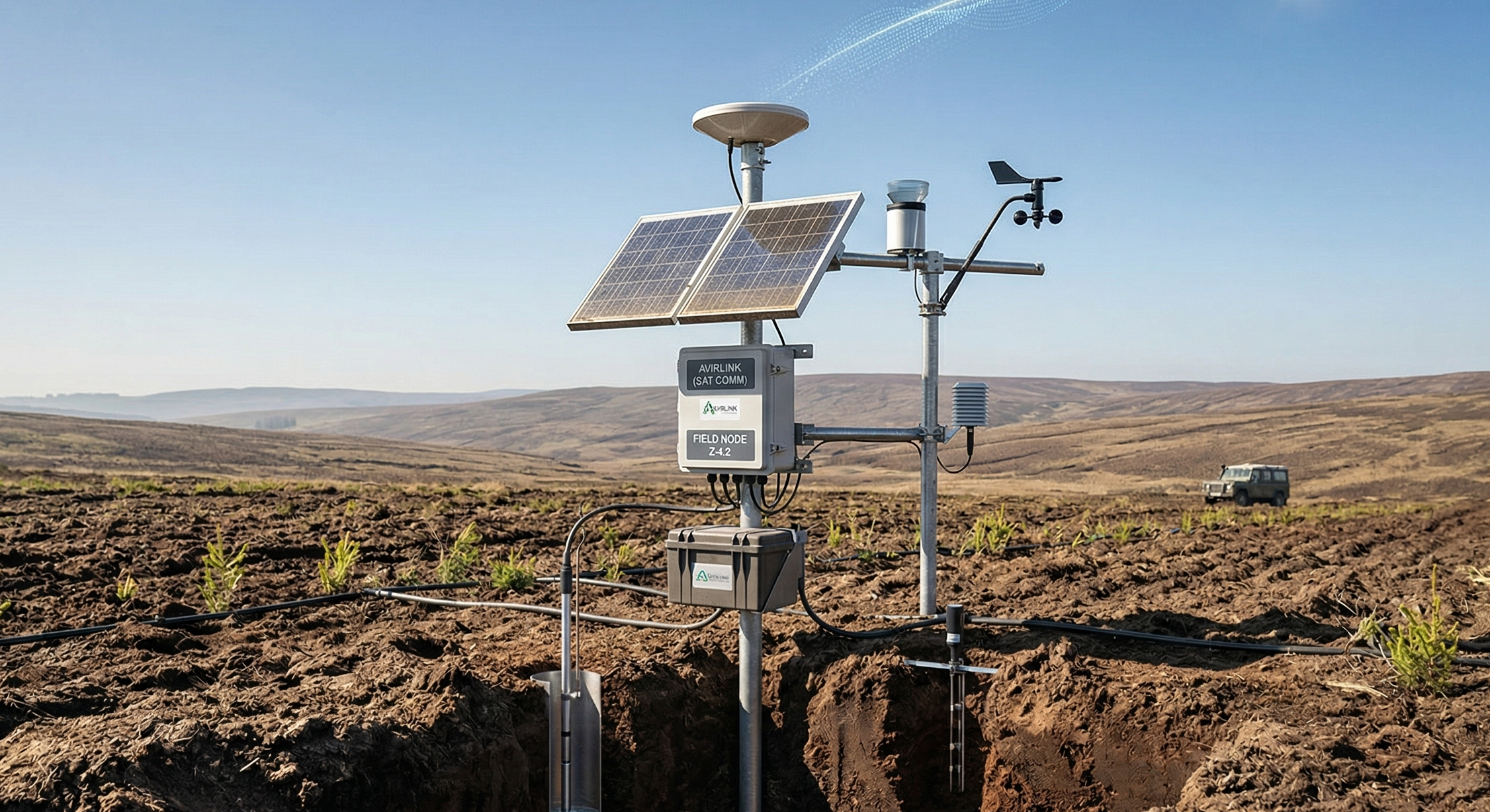
Avirlink S (Satellite) Telemetry System Overview
A system such as Avirlink provides a robust solution for remote data transmission by combining:
Satellite connectivity for global coverage
Solar-powered operation for energy independence
Durable hardware design for harsh field environments
Multi-sensor integration for flexible monitoring
This enables plantations to build a reliable data network across large and remote operational areas.
Enabling True Field-Level Monitoring
With satellite telemetry, sensors can be installed directly at critical monitoring points, such as:
Remote plantation blocks
Peatland and water-sensitive zones
Irrigation-critical areas
High-risk fire zones
Newly developed or undeveloped land
This ensures that data reflects actual field conditions, rather than approximations from distant locations.
Power Independence for Continuous Operation
One of the key challenges in remote deployments is the lack of power infrastructure. Satellite telemetry systems address this through:
Solar-powered modules, ensuring continuous energy supply
Rechargeable battery systems, providing backup during low sunlight conditions
This allows sensors and telemetry devices to operate continuously without requiring external power sources.
Reliable Data Transmission from Any Location
Satellite-enabled telemetry ensures that data collected in the field can be transmitted reliably to central systems.
Key advantages include:
Coverage in areas without cellular signal
Consistent data transmission regardless of terrain
Reduced dependency on local infrastructure
This reliability is critical for applications that require continuous monitoring, such as weather tracking, water level management, and environmental compliance.
Supporting Multiple Sensor Applications
The telemetry system is designed to support a wide range of sensors, enabling diverse monitoring use cases:
Weather monitoring (temperature, humidity, rainfall, wind)
Soil monitoring (moisture, temperature, conductivity)
Water level and water table (TMAT) monitoring
Water quality measurement
Air quality and environmental sensors
This flexibility allows plantation operators to expand their monitoring capabilities over time.
Data Integration and Centralized Access
Data transmitted via satellite is integrated into centralized platforms, where it can be:
Stored securely
Visualized through dashboards
Analyzed for trends and patterns
Used for alerts and notifications
This ensures that data collected from remote areas becomes part of the broader plantation intelligence system.
Enhancing Decision-Making with Accurate Field Data
By enabling data collection at precise field locations, satellite telemetry improves the quality of insights available to plantation managers.
This supports:
More accurate irrigation planning
Better timing of field operations
Early detection of environmental risks
Improved response to changing conditions
Decisions are no longer based on assumptions or incomplete data, but on direct measurements from the field.
Supporting Environmental Monitoring and Compliance
In many plantation environments, particularly in sensitive ecosystems, monitoring is required for regulatory compliance.
Satellite telemetry enables:
Continuous monitoring of key environmental parameters
Reliable data collection for reporting purposes
Verification of compliance with environmental standards
This is especially important for applications such as peatland management and water table monitoring.
Field Application Scenario
In a typical deployment, telemetry devices are installed alongside sensors in remote plantation areas. These devices collect data and transmit it via satellite to a central platform, ensuring continuous visibility regardless of location constraints.
Managers can access this data from anywhere, monitor conditions across different zones, and respond when thresholds are reached. This enables faster and more accurate decision-making, especially in areas that are difficult to access physically.
For example, a water level sensor installed in a remote peatland area can continuously transmit data, allowing managers to maintain optimal water levels and reduce fire risk. Instead of relying on periodic manual checks, the system provides consistent and traceable measurements directly from the field.
This approach also extends to weather monitoring deployments. In many cases, Automatic Weather Stations are installed in locations that represent specific micro-area conditions rather than near operational offices. In such setups, the telemetry device functions as the core transmission layer, enabling the weather station to operate independently of local infrastructure.
By integrating a telemetry unit as part of the weather station system, data such as temperature, humidity, rainfall, and wind conditions can be transmitted directly from the exact location being monitored. This ensures that environmental data reflects real field conditions, not approximations from distant points.
The combination of field sensors and satellite-enabled telemetry effectively transforms isolated monitoring devices into fully connected data nodes. Whether deployed for water level monitoring, weather observation, or soil measurement, the system ensures that every critical point in the plantation can contribute reliable data to the overall operational intelligence framework.
Scalability Across Plantation Networks
Satellite telemetry systems are designed to scale across large plantation operations.
Operators can:
Deploy additional sensors as needed
Expand monitoring coverage to new areas
Integrate new data sources into existing systems
This scalability supports long-term digital transformation initiatives.
Long-Term Impact on Plantation Operations
The adoption of satellite telemetry provides several long-term benefits:
Improved accuracy of environmental data
Greater operational visibility across remote areas
Reduced reliance on manual data collection
Enhanced ability to manage risks and resources
Stronger foundation for data-driven decision-making
By enabling connectivity without infrastructure constraints, plantations can fully utilize the potential of field-based monitoring systems.
Conclusion: Connecting the Unconnected Field
Connectivity has long been a limiting factor in deploying effective monitoring systems in plantation environments. Satellite telemetry solutions such as Avirlink remove this limitation by enabling reliable data transmission from any location.
By supporting location-specific measurements, independent power systems, and multi-sensor integration, the system allows plantation operators to collect accurate data where it matters most.
This transforms remote and previously inaccessible areas into connected sources of intelligence, enabling more informed decisions, improved risk management, and a stronger foundation for modern plantation operations.
Related blog posts
Products⎯Apr 03, 2026
Improving Fertilizer Distribution Efficiency in Forestry Environments Using High-Capacity Aerial Spreading Systems
Products⎯Mar 28, 2026
Enhancing Manual Spraying Operations with IoT-Enabled Smart Knapsack Systems for Accountability and Precision
Products⎯Mar 28, 2026
Managing Water Table (TMAT) in Plantation Environments Using Sensor-Based Monitoring Systems